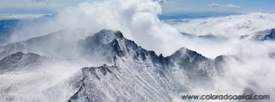
Here is one of our favorite panorama pictures of Long's Peak in the winter. This picture won Best in Show and Best Scenic photograph in the
Professional Aerial Photography Association (PAPA) 2010 Annual Conference. It also won a Judges Favorite award.

It was impressive to be in the plane to see this picture. The picture was taken in March 2009 from an altitude of approximately 15,000'. It is looking at the Northwest ridge of Long's Peak where the Keyhole landmark and hiking route is located. Long's Peak is 14,255' high, is located in
Rocky Mountain National Park, and is a prominent peak in the Denver skyline.
The typical summer hiking path will go from the snowy basin on the left corner called the Boulder Field and across the ridge in the center at a low point called the Keyhole, along the right side of the mountain in the Trough, across the ridge on the right near the top, and then to the top of the mountain through the Narrows and the Homestretch. A
good description of the hiking route can be found at 14ers.com. The Cable route goes straight up from the Boulder Field, and the Diamond routes are on the opposite side of the mountain.
A large print really shows the detail well and captures the beautiful view. If you have interest in using this photograph or purchasing a print, please contact Debbie at
debbie@coloradoaerial.com or 303-641-9528.

